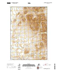
2018 Map of Hagemeister Island D-4 NE
USGS Topo · Published 2018About this map
Downdraft Mtn anchors the eastern interior of this coastal terrain, rising above a vast network of wetlands and tundra streams. The landscape is defined by the transition between the Bethel Census Area and the Dillingham Census Area, a boundary line that cuts through the drainage basins of several important regional waterways. Two primary rivers provide the vital hydrological structure for this territory: the Osviak River meanders along the western edge, while the Nisue River flows through the northeastern corner. These river systems, captured here in 2018, serve as the historical and geographical arteries for a region largely defined by its natural water flow and seasonal wetlands. The map provides a high-resolution record of the Public Land Survey System grids, including t14s r71w and t15s r70w, which are essential for pinpointing land claims and ancestral territories in this remote section of Alaska.
Find a feature on this map
8 named features on this map. Tap any name to fly to it.
Don’t see what you’re looking for? This feature index may not catch every label — zoom into the map to look around manually.
Map Details
Editions of this 2018 Hagemeister Island D-4 NE Map
This is the sole edition of this map. No revisions or reprints were ever made.
Other maps of this area

1948 · Hagemeister Island D-3
USGS Topo · 1:63,360

1951 · Goodnews
USGS Topo · 1:250,000

1951 · Hagemeister Island
USGS Topo · 1:250,000

1954 · Hagemeister Island D-4
USGS Topo · 1:63,360

1954 · Goodnews A-6
USGS Topo · 1:63,360

1957 · Hagemeister Island
USGS Topo · 1:250,000

1979 · Goodnews Bay
USGS Topo · 1:250,000
2017 · Goodnews Bay A-6 SW
USGS Topo · 1:25,000
2018 · Hagemeister Island D-3 NW
USGS Topo · 1:25,000
2018 · Hagemeister Island D-3 SW
USGS Topo · 1:25,000