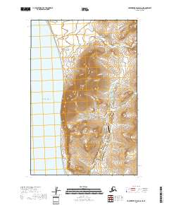
2018 Map of Hagemeister Island D-6 NE
USGS Topo · Published 2018About this map
Industrial activity and coastal topography converge at Platinum, where the Salmon River drainage meets the Pacific Ocean. This 2018 survey illustrates a landscape shaped by mineral extraction, centered on the Goodnews Mining Camp and the Platinum Mine Airport. The terrain is dominated by the steep rises of Red Mtn and Thorsen Mtn, which overlook a complex network of streams and gulches such as Fox Gulch and Dry Gulch. The presence of Red Mountain Road and its extension indicates continued logistical access to these remote operations. At the shoreline, the prominent Flat Cape stands as a navigational landmark south of the town. The intricate drainage patterns of Seattle Cr and Smalls River highlight the hydrological importance of this mining district at the edge of the Bering Sea.
Find a feature on this map
29 named features on this map. Tap any name to fly to it.
Don’t see what you’re looking for? This feature index may not catch every label — zoom into the map to look around manually.
Map Details
Editions of this 2018 Hagemeister Island D-6 NE Map
This is the sole edition of this map. No revisions or reprints were ever made.
Other maps of this area

1950 · Hagemeister Island D-6
USGS Topo · 1:63,360

1950 · Hagemeister Island D-5
USGS Topo · 1:63,360

1951 · Goodnews
USGS Topo · 1:250,000

1951 · Hagemeister Island
USGS Topo · 1:250,000

1954 · Goodnews A-8
USGS Topo · 1:63,360

1954 · Hagemeister Island D-5
USGS Topo · 1:63,360

1957 · Hagemeister Island
USGS Topo · 1:250,000

1979 · Goodnews Bay
USGS Topo · 1:250,000
2017 · Goodnews Bay A-8 SE
USGS Topo · 1:25,000
2017 · Goodnews Bay A-8 SW
USGS Topo · 1:25,000