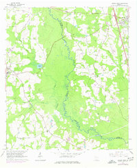
1961 Map of Hahira West
USGS Topo · Published 1977About this map
The Little River forms a winding natural boundary between Brooks and Lowndes counties, carving a path through a landscape of wetlands and small agricultural settlements. This 1961 survey, updated with 1974 aerial revisions, captures the rural character of the region just as modern infrastructure began to expand. In the western portion of the map, Morven sits at a crossroads, while the larger town of Hahira occupies the northeastern corner, supported by the Southern railroad line.
Find a feature on this map
31 named features on this map. Tap any name to fly to it.
Don’t see what you’re looking for? This feature index may not catch every label — zoom into the map to look around manually.
Map Details
Editions of this 1961 Hahira West Map
2 editions found
Other maps of this area

1953 · Waycross
USGS Topo · 1:250,000

1954 · Valdosta
USGS Topo · 1:250,000

1958 · Valdosta
USGS Topo · 1:250,000

1958 · Waycross
USGS Topo · 1:250,000

1959 · Valdosta
USGS Topo · 1:250,000

1961 · Hahira East
USGS Topo · 1:24,000

1961 · Quitman
USGS Topo · 1:62,500

1961 · Valdosta
USGS Topo · 1:24,000

1961 · Hahira West
USGS Topo · 1:24,000

1961 · Ousley
USGS Topo · 1:24,000