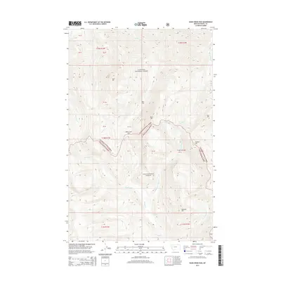
2014 Map of Hahn Creek Pass
USGS Topo · Published 2014About this map
Hahn Creek Pass serves as a geographic threshold between the Flathead National Forest and the Lolo National Forest in Powell County. This 2014 survey details a landscape defined by sharp elevation shifts and a complex network of high-altitude drainages. The area is dominated by several named peaks including Gust Mtn, Moser Mtn, and Foolhen Mtn, which frame the deep valleys carved by Hahn Cr and Monture Cr. The convergence of these two national forests is particularly notable, as the boundary follows the high ridges through the pass, separating the northern waters flowing toward Youngs Cr from the southern tributaries like Middle Fork Monture Cr. This map provides clear documentation of the public land survey system and topographic character of the northern Rockies at the start of the twenty-first century.
Find a feature on this map
24 named features on this map. Tap any name to fly to it.
Don’t see what you’re looking for? This feature index may not catch every label — zoom into the map to look around manually.
Map Details
Editions of this 2014 Hahn Creek Pass Map
This is the sole edition of this map. No revisions or reprints were ever made.
Other maps of this area

1902 · Ovando
USGS Topo · 1:125,000

1905 · Ovando
USGS Topo · 1:125,000

1955 · Choteau
USGS Topo · 1:250,000

1957 · Choteau
USGS Topo · 1:250,000

1958 · Choteau
USGS Topo · 1:250,000

1962 · Choteau
USGS Topo · 1:250,000

1965 · Morrell Mountain
USGS Topo · 1:24,000

1968 · Spread Mountain
USGS Topo · 1:24,000

1968 · Dunham Point
USGS Topo · 1:24,000
1970 · Crimson Peak
USGS Topo · 1:24,000