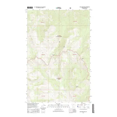
2017 Map of Hahn Creek Pass
USGS Topo · Published 2017About this map
The Continental Divide serves as a natural boundary in this high-elevation wilderness, where the Flathead National Forest meets the Lolo National Forest. Centered on the eponymous Hahn Creek Pass, the landscape is defined by a network of drainage basins including Hahn Creek, Foolhen Creek, and Delaware Creek. The hydrology of the region is particularly striking, with the Middle Fork Monture Creek and Monture Creek flowing southward toward the Monture Falls.
Find a feature on this map
23 named features on this map. Tap any name to fly to it.
Don’t see what you’re looking for? This feature index may not catch every label — zoom into the map to look around manually.
Map Details
Editions of this 2017 Hahn Creek Pass Map
This is the sole edition of this map. No revisions or reprints were ever made.
Other maps of this area

1902 · Ovando
USGS Topo · 1:125,000

1905 · Ovando
USGS Topo · 1:125,000

1955 · Choteau
USGS Topo · 1:250,000

1957 · Choteau
USGS Topo · 1:250,000

1958 · Choteau
USGS Topo · 1:250,000

1962 · Choteau
USGS Topo · 1:250,000

1965 · Morrell Mountain
USGS Topo · 1:24,000

1968 · Spread Mountain
USGS Topo · 1:24,000

1968 · Dunham Point
USGS Topo · 1:24,000
1970 · Crimson Peak
USGS Topo · 1:24,000