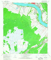
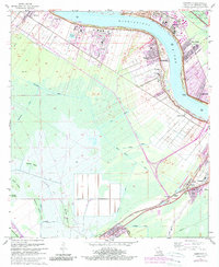
1967 Map of Hahnville
USGS Topo · Published 1968About this map
The Mississippi River creates a dramatic crescent through this 1960s landscape, serving as the industrial and residential spine for Hahnville and surrounding communities. Heavy industry and infrastructure are prominent, from the Waterworks and Sewage Disposal facilities to the Good Hope Oil and Gas Field. The settlement pattern follows the river's high ground, where places like New Sarpy, Destrehan, and Taft are tightly packed between the water and the vast wetlands to the south. Further inland, the rail-oriented towns of Paradis and Boutte sit at the edge of an extensive swamp network characterized by landmarks like Cypress Island and Bird Island. The transition from the engineered Bonnet Carre Floodway to the complex drainage of the Ellington Canal and Crocodile Bayou illustrates the constant management of water in St Charles Parish. Local life is anchored by institutions such as Holy Rosary Ch and Carver High Sch.
Find a feature on this map
42 named features on this map. Tap any name to fly to it.
Don’t see what you’re looking for? This feature index may not catch every label — zoom into the map to look around manually.
Map Details
Editions of this 1967 Hahnville Map
5 editions found
Other maps of this area

1891 · Hahnville
USGS Topo · 1:62,500

1892 · Lac Des Allemands
USGS Topo · 1:62,500

1892 · Mount Airy
USGS Topo · 1:62,500

1892 · Bonnet Carre
USGS Topo · 1:62,500

1932 · Lac Des Allemands SE
USGS Topo · 1:31,680

1932 · Hahnville NW
USGS Topo · 1:31,680

1932 · Lac Des Allemands NE
USGS Topo · 1:31,680

1932 · Hahnville SW
USGS Topo · 1:31,680

1932 · Hahnville NE
USGS Topo · 1:31,680

1935 · Laplace
USGS Topo · 1:31,680