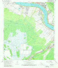
1967 Map of Hahnville
USGS Topo · Published 1973About this map
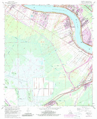
The Mississippi River defines this 1967 landscape of St Charles Parish, where the industrial corridor of the River Road meets the expansive wetlands of the Louisiana coast. The parish seat at Hahnville is anchored by the Courthouse and Holy Rosary Ch, while the surrounding riverfront is dotted with industrial footprints like the Refinery at Good Hope and the industrial waste sites near Taft. Parallel to the river, a complex network of drainage canals including the St Charles Canal and Hymel Canal crisscrosses the low-lying terrain toward the interior marshes. To the southwest, the Johnson Gas Field occupies the swampy reaches between Cypress Island and Bird Island. The transition from river commerce to rail-driven economy is evident in the alignment of the Texas and Pacific and Southern Pacific railroads, which link the river towns to inland settlements like Boutte and Paradis.
Find a feature on this map
55 named features on this map. Tap any name to fly to it.
Don’t see what you’re looking for? This feature index may not catch every label — zoom into the map to look around manually.
Map Details
Editions of this 1967 Hahnville Map
5 editions found
Other maps of this area

1891 · Hahnville
USGS Topo · 1:62,500

1892 · Lac Des Allemands
USGS Topo · 1:62,500

1892 · Mount Airy
USGS Topo · 1:62,500

1892 · Bonnet Carre
USGS Topo · 1:62,500

1932 · Lac Des Allemands SE
USGS Topo · 1:31,680

1932 · Hahnville NW
USGS Topo · 1:31,680

1932 · Lac Des Allemands NE
USGS Topo · 1:31,680

1932 · Hahnville SW
USGS Topo · 1:31,680

1932 · Hahnville NE
USGS Topo · 1:31,680

1935 · Laplace
USGS Topo · 1:31,680