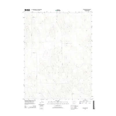
2014 Map of Haigler NW
USGS Topo · Published 2014About this map
Buffalo Cr winds through the southwestern corner of this Dundy County landscape, providing a rare water source in an otherwise high-plains environment. This 2014 representation of the Nebraska panhandle highlights a geometric grid of rural transit, where Haigler Rd and Harford Rd serve as the primary north-south arteries. The terrain is defined by soft elevation changes and a scattered network of section-line roads, such as Road 719 along the northern boundary and Road 711 to the south. This area demonstrates the expansive nature of modern Nebraska ranching and agricultural land divisions, where the infrastructure is built around the efficiency of the section and township system. Local researchers can trace the specific path of Road 712A and Road 716 as they provide access to this open country northwest of Haigler.
Find a feature on this map
7 named features on this map. Tap any name to fly to it.
Don’t see what you’re looking for? This feature index may not catch every label — zoom into the map to look around manually.
Map Details
Editions of this 2014 Haigler NW Map
This is the sole edition of this map. No revisions or reprints were ever made.
Other maps of this area

1954 · Sterling
USGS Topo · 1:250,000

1954 · McCook
USGS Topo · 1:250,000

1957 · McCook
USGS Topo · 1:250,000

1958 · McCook
USGS Topo · 1:250,000

1958 · Sterling
USGS Topo · 1:250,000
1961 · Rock Creek Lake
USGS Topo · 1:24,000
1961 · Haigler
USGS Topo · 1:24,000

1961 · Laird
USGS Topo · 1:24,000

1971 · Alvin
USGS Topo · 1:24,000

1971 · Wray NE
USGS Topo · 1:24,000