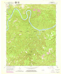
1963 Map of Hail
USGS Topo · Published 1979About this map
The Cumberland River Lake dominates this 1963 survey of the rugged borderlands between Pulaski and McCreary counties. This revision highlights the impact of controlled inundation, noting the lake's normal pool elevation of 723 feet and the winding geometry of Barnett Bend and Jasper Bend. Inland from the river, the landscape is defined by the steep ridges of the Daniel Boone National Forest, where small settlements like Hail and Blue John sit among deep hollows. The southern edge of the map tracks the Southern Railway through Greenwood, providing a glimpse into the rail-dependent economy of the era. Historical researchers can identify several isolated country churches, including Salem Ch and Bethel Ch, and trace the primitive road network through the Beaver Creek Wilderness, alongside family landmarks such as Hyden Ridge and Hewling Ridge.
Find a feature on this map
82 named features on this map. Tap any name to fly to it.
Don’t see what you’re looking for? This feature index may not catch every label — zoom into the map to look around manually.
Map Details
Editions of this 1963 Hail Map
4 editions found
Other maps of this area

1890 · Williamsburg
USGS Topo · 1:125,000

1893 · London
USGS Topo · 1:125,000

1894 · Williamsburg
USGS Topo · 1:125,000

1897 · London
USGS Topo · 1:125,000

1932 · Burnside
USGS Topo · 1:62,500

1935 · Somerset
USGS Topo · 1:62,500

1952 · Hail
USGS Topo · 1:24,000

1952 · Ano
USGS Topo · 1:24,000

1952 · Wiborg
USGS Topo · 1:24,000

1952 · Cumberland Falls
USGS Topo · 1:24,000