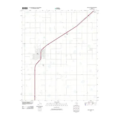
2010 Map of Hale Center
USGS Topo · Published 2010About this map
Hale Center serves as the focal point of this High Plains landscape, where the grid of agricultural land is intersected by the diagonal sweep of Interstate 27. The town's layout is clearly defined alongside the Hale Center Cemetery to the northwest, illustrating the organized growth of this Llano Estacado community. Beyond the main settlement, the map records smaller locales like Six Point and Furguson, which reflect the dispersed nature of rural Texas ranching and farming life. A network of farm-to-market roads, including Fm 1914 and Fm 1424, links the various sections of the county. The terrain is notably marked by numerous small depressions or playas, characteristic of the region's hydrology, and is bordered by named local routes such as Hi-Line Rd and Sun Rd.
Find a feature on this map
24 named features on this map. Tap any name to fly to it.
Don’t see what you’re looking for? This feature index may not catch every label — zoom into the map to look around manually.
Map Details
Editions of this 2010 Hale Center Map
This is the sole edition of this map. No revisions or reprints were ever made.
Other maps of this area

1954 · Lubbock
USGS Topo · 1:250,000

1954 · Plainview
USGS Topo · 1:250,000

1957 · Abernathy
USGS Topo · 1:62,500

1958 · Plainview
USGS Topo · 1:250,000

1965 · Wasson
USGS Topo · 1:24,000

1965 · Plainview
USGS Topo · 1:24,000

1968 · Halfway
USGS Topo · 1:24,000

1968 · Happy Union
USGS Topo · 1:24,000

1968 · Julia Lake
USGS Topo · 1:24,000
1968 · Hale Center SW
USGS Topo · 1:24,000