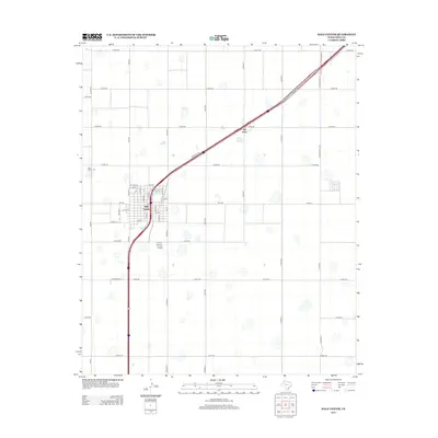
2012 Map of Hale Center
USGS Topo · Published 2012About this map
Hale Center serves as the focal point of this High Plains landscape, where the grid-based agricultural layout of Hale County is interrupted by the diagonal sweep of the interstate. The town's local geography is defined by a traditional street plan featuring Main St, Avenue K, and Ewalt St, providing a clear view of the community's layout in the early 21st century. To the northwest, the Hale Center Cem stands as a primary landmark for genealogists and local historians tracing family roots in this part of Texas.
Find a feature on this map
45 named features on this map. Tap any name to fly to it.
Don’t see what you’re looking for? This feature index may not catch every label — zoom into the map to look around manually.
Map Details
Editions of this 2012 Hale Center Map
This is the sole edition of this map. No revisions or reprints were ever made.
Other maps of this area

1954 · Lubbock
USGS Topo · 1:250,000

1954 · Plainview
USGS Topo · 1:250,000

1957 · Abernathy
USGS Topo · 1:62,500

1958 · Plainview
USGS Topo · 1:250,000

1965 · Wasson
USGS Topo · 1:24,000

1965 · Plainview
USGS Topo · 1:24,000

1968 · Halfway
USGS Topo · 1:24,000

1968 · Happy Union
USGS Topo · 1:24,000

1968 · Julia Lake
USGS Topo · 1:24,000
1968 · Hale Center SW
USGS Topo · 1:24,000