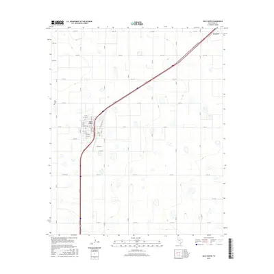
2016 Map of Hale Center
USGS Topo · Published 2016About this map
Hale Center serves as the focal point of this high plains agricultural landscape, organized by a strict grid of county roads that define the region's ranching and farming heritage. The town's layout is centered around several numbered streets such as W 14th St and W 5th St, while the nearby Hale Center Cem offers a primary point of interest for genealogists tracing local family roots. A series of service roads, including E Svc Rd and W Svc Rd, parallel the major transportation corridor that cuts diagonally across the northern portion of the map towards the settlement of Furguson. The surrounding terrain is marked by numerous ephemeral basins and depressions, typical of this portion of the Texas Panhandle, connected by arterial routes like Hi-Line Rd and Sun Rd.
Find a feature on this map
48 named features on this map. Tap any name to fly to it.
Don’t see what you’re looking for? This feature index may not catch every label — zoom into the map to look around manually.
Map Details
Editions of this 2016 Hale Center Map
This is the sole edition of this map. No revisions or reprints were ever made.
Other maps of this area

1954 · Lubbock
USGS Topo · 1:250,000

1954 · Plainview
USGS Topo · 1:250,000

1957 · Abernathy
USGS Topo · 1:62,500

1958 · Plainview
USGS Topo · 1:250,000

1965 · Wasson
USGS Topo · 1:24,000

1965 · Plainview
USGS Topo · 1:24,000

1968 · Halfway
USGS Topo · 1:24,000

1968 · Happy Union
USGS Topo · 1:24,000

1968 · Julia Lake
USGS Topo · 1:24,000
1968 · Hale Center SW
USGS Topo · 1:24,000