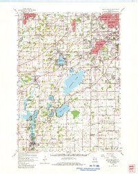
1959 Map of Hales Corners
USGS Topo · Published 1980About this map
Muskego Lake and its surrounding wetlands dominate this 1959 landscape, capturing the area during a period of significant suburban expansion from Waukesha and Milwaukee. The map documents a dense network of local education and faith, featuring numerous country schoolhouses like Echo Glen Sch and Lake Denoon Sch, alongside established centers such as Hales Corners and Greendale. The terrain is defined by glacial features, including Little Muskego Lake, Wind Lake, and the winding path of the Fox River to the southwest.
Find a feature on this map
133 named features on this map. Tap any name to fly to it.
Don’t see what you’re looking for? This feature index may not catch every label — zoom into the map to look around manually.
Map Details
Editions of this 1959 Hales Corners Map
This is the sole edition of this map. No revisions or reprints were ever made.
Other maps of this area

1891 · Bayview
USGS Topo · 1:62,500

1891 · Muskego
USGS Topo · 1:62,500

1892 · Milwaukee
USGS Topo · 1:62,500

1892 · Waukesha
USGS Topo · 1:62,500

1892 · Racine
USGS Topo · 1:62,500

1892 · Oconomowoc
USGS Topo · 1:62,500

1892 · Eagle
USGS Topo · 1:62,500

1893 · Silver Lake
USGS Topo · 1:62,500

1893 · Geneva
USGS Topo · 1:62,500

1894 · Eagle
USGS Topo · 1:62,500