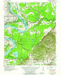
1952 Map of Hales Point
USGS Topo · Published 1960About this map
Mississippi River Needham Cut-Off (1821) dominates the central hydrology of this survey, where the river divides Mississippi County, Arkansas, from Lauderdale County, Tennessee. The landscape is a complex of abandoned river bends and active waterways like the Forked Deer River, which snakes through Moss Island before meeting the main channel. This mid-century view captures the transition from the low-lying river bottoms and sloughs like Bostic Slough to the higher ground near Ripley. The social fabric of these rural river towns is mapped through numerous dual-purpose community centers, including the Henning Grove Church and School and Matthews Church and School. Transportation history is preserved in the location of the Gypsy Ferry and the Forked Deer Electric Co infrastructure, reflecting the industrial and logistical requirements of managing a major floodplain just after the war years.
Find a feature on this map
67 named features on this map. Tap any name to fly to it.
Don’t see what you’re looking for? This feature index may not catch every label — zoom into the map to look around manually.
Map Details
Editions of this 1952 Hales Point Map
4 editions found
Other maps of this area

1939 · Dyersburg
USGS Topo · 1:62,500

1939 · Hales Point
USGS Topo · 1:62,500

1939 · Caruthersville
USGS Topo · 1:62,500

1939 · Halls
USGS Topo · 1:62,500

1939 · Blytheville
USGS Topo · 1:62,500

1940 · Hayti
USGS Topo · 1:62,500

1951 · Caruthersville
USGS Topo · 1:62,500

1952 · Hales Point
USGS Topo · 1:62,500

1952 · Gates
USGS Topo · 1:24,000

1952 · Dyersburg
USGS Topo · 1:24,000