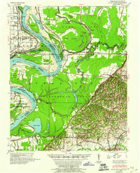
1952 Map of Hales Point
USGS Topo · Published 1960About this map
The Mississippi River dominates this landscape, defining the volatile border between Tennessee and Arkansas with its complex system of chutes, islands, and historical alterations. The Needham Cut-Off (1821) and Blue Grass Towhead illustrate the river's evolving course, while Gypsy Ferry provides a glimpse into mid-century river crossings at Hales Point. The floodplain is crisscrossed by the Forked Deer River and Obion River, which feed into numerous oxbows like Chisholm Lake and Open Lake.
Find a feature on this map
72 named features on this map. Tap any name to fly to it.
Don’t see what you’re looking for? This feature index may not catch every label — zoom into the map to look around manually.
Map Details
Editions of this 1952 Hales Point Map
4 editions found
Other maps of this area

1939 · Dyersburg
USGS Topo · 1:62,500

1939 · Hales Point
USGS Topo · 1:62,500

1939 · Caruthersville
USGS Topo · 1:62,500

1939 · Halls
USGS Topo · 1:62,500

1939 · Blytheville
USGS Topo · 1:62,500

1940 · Hayti
USGS Topo · 1:62,500

1951 · Caruthersville
USGS Topo · 1:62,500

1952 · Hales Point
USGS Topo · 1:62,500

1952 · Gates
USGS Topo · 1:24,000

1952 · Dyersburg
USGS Topo · 1:24,000