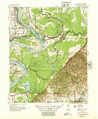
1952 Map of Hales Point
USGS Topo · Published 1952About this map
The Mississippi River creates a dynamic western boundary for Tennessee in this mid-century survey, highlighted by the Needham Cut-Off which altered the river's course over a century prior. The landscape of Lauderdale County and Dyer County is defined by an intricate network of waterways including the Obion River, Forked Deer River, and numerous oxbows like Open Lake and Chisholm Lake. Local life is anchored by family and community institutions, often pairing education and faith at sites like Henning Grove Church and School and Cane Ridge Church and School. Numerous landings such as Hickman Ldg and Wrights Point Ldg underscore the importance of river access, while inland settlements like Ripley and Arp serve as agricultural hubs connected by early drainage infrastructure like Ditch No 1.
Find a feature on this map
83 named features on this map. Tap any name to fly to it.
Don’t see what you’re looking for? This feature index may not catch every label — zoom into the map to look around manually.
Map Details
Editions of this 1952 Hales Point Map
4 editions found
Other maps of this area

1939 · Dyersburg
USGS Topo · 1:62,500

1939 · Hales Point
USGS Topo · 1:62,500

1939 · Caruthersville
USGS Topo · 1:62,500

1939 · Halls
USGS Topo · 1:62,500

1939 · Blytheville
USGS Topo · 1:62,500

1940 · Hayti
USGS Topo · 1:62,500

1951 · Caruthersville
USGS Topo · 1:62,500

1952 · Hales Point
USGS Topo · 1:62,500

1952 · Gates
USGS Topo · 1:24,000

1952 · Dyersburg
USGS Topo · 1:24,000