
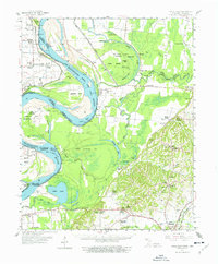
1961 Map of Hales Point
USGS Topo · Published 1963About this map
The Mississippi River defines this landscape in the early 1960s, its meandering course creating a complex system of islands, bends, and sloughs across the Tennessee-Arkansas state line. The Needham Cut-off remains a prominent hydrological marker, bypassed by the modern channel but still shaping the local terrain near Wrights Point. On the Tennessee side, the town of Ripley serves as a regional hub, connected to smaller communities like Arp and Edith by a network of winding roads. This area is characterized by its deep connection to the river economy and wetlands, evidenced by the Moss Island Waterfowl Management Area and numerous family-named landmarks. Genealogists will find a wealth of local-history markers, including Henning Grove Ch & Sch, St Luke Cem, and Ashport Ch, which highlight the scattered rural settlements and social centers of Lauderdale County during this era.
Find a feature on this map
80 named features on this map. Tap any name to fly to it.
Don’t see what you’re looking for? This feature index may not catch every label — zoom into the map to look around manually.
Map Details
Editions of this 1961 Hales Point Map
2 editions found
Other maps of this area

1939 · Dyersburg
USGS Topo · 1:62,500

1939 · Hales Point
USGS Topo · 1:62,500

1939 · Caruthersville
USGS Topo · 1:62,500

1939 · Halls
USGS Topo · 1:62,500

1939 · Blytheville
USGS Topo · 1:62,500

1940 · Hayti
USGS Topo · 1:62,500

1951 · Caruthersville
USGS Topo · 1:62,500

1952 · Hales Point
USGS Topo · 1:62,500

1952 · Gates
USGS Topo · 1:24,000

1952 · Dyersburg
USGS Topo · 1:24,000