
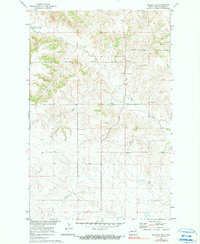
1970 Map of Halliday NE
USGS Topo · Published 1973About this map
The Fort Berthold Indian Reservation boundary cuts through the northern half of this landscape, marking a transition between tribal lands and the surrounding rural plains of Dunn County. This 1970 field check captures the area after the creation of the Garrison Dam, with the waters of Lake Sakakawea reaching into the northwest corner via Hay Coulee. The terrain is defined by the winding paths of Hans Creek and Steel Creek, which carve deep drainage patterns through the prairie. Near the center of the sheet, the presence of St Johns Cem provides a specific point of interest for genealogists and local historians, while a prominent Pipeline running through the southern section indicates the region's developing energy infrastructure during the late twentieth century.
Find a feature on this map
9 named features on this map. Tap any name to fly to it.
Don’t see what you’re looking for? This feature index may not catch every label — zoom into the map to look around manually.
Map Details
Editions of this 1970 Halliday NE Map
2 editions found
Other maps of this area

1953 · Watford City
USGS Topo · 1:250,000

1957 · Watford City
USGS Topo · 1:250,000

1967 · Watford City
USGS Topo · 1:250,000

1967 · Twin Buttes
USGS Topo · 1:24,000

1970 · Hay Flat
USGS Topo · 1:24,000

1970 · Golden Valley NW
USGS Topo · 1:24,000

1970 · Halliday NW
USGS Topo · 1:24,000
1970 · Saddle Butte SW
USGS Topo · 1:24,000

1973 · Halliday
USGS Topo · 1:24,000

1973 · Dodge
USGS Topo · 1:24,000