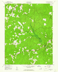
1943 Map of Hallsboro
USGS Topo · Published 1961About this map
The Southern Railroad railroad line cuts through the northern reaches of Chesterfield County, connecting the small settlement at Hallsboro to the surrounding rural landscape during the early 1940s. This survey, conducted just as the region remained primarily agricultural and forested, shows a network of creeks and branches that defined local property lines and travel routes. Significant drainage systems such as Swift Creek and Deep Creek provide the primary topographic structure, while the presence of landmarks like Dry Bridge indicates established transport crossings over the rail corridor.
Find a feature on this map
21 named features on this map. Tap any name to fly to it.
Don’t see what you’re looking for? This feature index may not catch every label — zoom into the map to look around manually.
Map Details
Editions of this 1943 Hallsboro Map
2 editions found
Other maps of this area

1890 · Goochland
USGS Topo · 1:125,000

1892 · Goochland
USGS Topo · 1:125,000

1897 · Amelia
USGS Topo · 1:125,000

1936 · Richmond West
USGS Topo · 1:24,000

1942 · Westhampton
USGS Topo · 1:31,680

1943 · Fine Creek Mills
USGS Topo · 1:31,680

1943 · Chesterfield
USGS Topo · 1:31,680

1943 · Goodes Bridge
USGS Topo · 1:31,680

1943 · Hallsboro
USGS Topo · 1:31,680

1943 · Beach
USGS Topo · 1:24,000