
1943 Map of Hallsboro
USGS Topo · Published 1943About this map
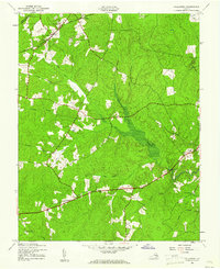
The Southern railroad corridor and a complex network of waterways define this corner of the Piedmont during the early 1940s. At the village of Hallsboro, the rail line intersects with local industry at Sawmill, while Dry Bridge marks a specific crossing point to the northeast. This area, spanning the border of Powhatan and Chesterfield counties, is characterized by its rural ecclesiastical landscape, featuring several prominent houses of worship such as Tomahawk Church, Chesterfield Church, and Brown Grove Church.
Find a feature on this map
30 named features on this map. Tap any name to fly to it.
Don’t see what you’re looking for? This feature index may not catch every label — zoom into the map to look around manually.
Map Details
Editions of this 1943 Hallsboro Map
2 editions found
Other maps of this area

1890 · Goochland
USGS Topo · 1:125,000

1892 · Goochland
USGS Topo · 1:125,000

1897 · Amelia
USGS Topo · 1:125,000

1936 · Richmond West
USGS Topo · 1:24,000

1942 · Westhampton
USGS Topo · 1:31,680

1943 · Fine Creek Mills
USGS Topo · 1:31,680

1943 · Chesterfield
USGS Topo · 1:31,680

1943 · Goodes Bridge
USGS Topo · 1:31,680

1943 · Beach
USGS Topo · 1:24,000

1943 · Clayville
USGS Topo · 1:24,000