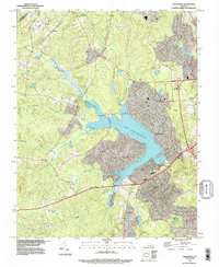
1994 Map of Hallsboro
USGS Topo · Published 1996About this map
Swift Creek Reservoir dominates the eastern half of this landscape, its fingers reaching into the surrounding drainage basins of Turkey Creek, Deep Creek, and West Branch. The planned community of Brandermill is established along the reservoir's shores, illustrating the late-twentieth-century residential shift in this part of Chesterfield County. The map shows a transition from the established suburban development near the water to the more dispersed rural character around Hallsboro and Otterdale to the west.
Find a feature on this map
23 named features on this map. Tap any name to fly to it.
Don’t see what you’re looking for? This feature index may not catch every label — zoom into the map to look around manually.
Map Details
Editions of this 1994 Hallsboro Map
This is the sole edition of this map. No revisions or reprints were ever made.
Other maps of this area

1890 · Goochland
USGS Topo · 1:125,000

1892 · Goochland
USGS Topo · 1:125,000

1897 · Amelia
USGS Topo · 1:125,000

1936 · Richmond West
USGS Topo · 1:24,000

1942 · Westhampton
USGS Topo · 1:31,680

1943 · Fine Creek Mills
USGS Topo · 1:31,680

1943 · Chesterfield
USGS Topo · 1:31,680

1943 · Goodes Bridge
USGS Topo · 1:31,680

1943 · Hallsboro
USGS Topo · 1:31,680

1943 · Beach
USGS Topo · 1:24,000