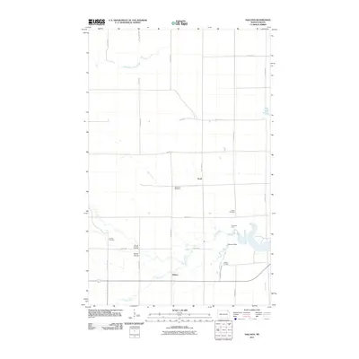
2011 Map of Hallson
USGS Topo · Published 2011About this map
Hallson and Svold anchor this rural landscape in Pembina County, where the Tongue River meanders across a grid of section-line roads. The area's cultural history is marked by several burial grounds, including the Old Peters Cemetery, Peters Cemetery, Andvari Cemetery, and Hallson Cemetery, reflecting the settlement patterns of early homesteading families. In the southeastern portion, the Morrison Dam and the northern reaches of Icelandic State Park indicate where local waterways have been modified for conservation and recreation. The geography is further defined by natural drainage features like Smith Coulee and Busse Coulee, which cut through the agricultural tableland. Small homesteads and operations like Pleasance Farm remain connected by an extensive network of North East avenues and streets, maintaining the township's traditional layout into the twenty-first century.
Find a feature on this map
25 named features on this map. Tap any name to fly to it.
Don’t see what you’re looking for? This feature index may not catch every label — zoom into the map to look around manually.
Map Details
Editions of this 2011 Hallson Map
This is the sole edition of this map. No revisions or reprints were ever made.
Other maps of this area

1918 · Walhalla
USGS Topo · 1:62,500

1939 · Cavalier
USGS Topo · 1:62,500

1941 · Cavalier
USGS Topo · 1:62,500

1943 · Walhalla
USGS Topo · 1:62,500

1944 · Crystal
USGS Topo · 1:62,500

1952 · Thief River Falls
USGS Topo · 1:250,000

1956 · Thief River Falls
USGS Topo · 1:250,000

1957 · Thief River Falls
USGS Topo · 1:250,000

1964 · Mountain
USGS Topo · 1:24,000
1964 · Hensel
USGS Topo · 1:24,000