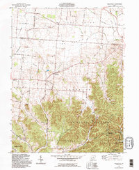
1992 Map of Hallsville
USGS Topo · Published 1995About this map
Tar Hollow State Forest dominates the southeastern quadrant of this region, where the ridge-and-hollow topography of the North Ridge contrasts sharply with the flat agricultural plains of The Prairie to the north. Small rural settlements like Whisler, Hallsville, and Adelphi serve as historic anchors along the Pickaway Co Ross Co County Line Road. The landscape is dotted with numerous family-named burial grounds and rural houses of worship, such as Salem Reform Ch and the Maple Grove Cem. Significant drainage systems including Salt Creek and Kinnikinnick Creek carve through the terrain, illustrating the transition from open farmland to the wooded elevations of Tar Hollow State Park. This area maintains a traditional rural character, with scattered Gravel Pits and a Racetrack near Adelphi indicating local industrial and recreational footprints.
Find a feature on this map
61 named features on this map. Tap any name to fly to it.
Don’t see what you’re looking for? This feature index may not catch every label — zoom into the map to look around manually.
Map Details
Editions of this 1992 Hallsville Map
This is the sole edition of this map. No revisions or reprints were ever made.
Other maps of this area

1906 · Chillicothe
USGS Topo · 1:62,500

1907 · Lancaster
USGS Topo · 1:62,500

1908 · Chillicothe
USGS Topo · 1:62,500

1909 · Lancaster
USGS Topo · 1:62,500

1910 · Laurelville
USGS Topo · 1:62,500

1912 · Laurelville
USGS Topo · 1:62,500

1914 · Circleville
USGS Topo · 1:62,500

1943 · Circleville
USGS Topo · 1:62,500

1944 · Laurelville
USGS Topo · 1:62,500

1947 · Columbus
USGS Topo · 1:250,000