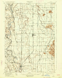
1912 Map of Halsey
USGS Topo · Published 1934About this map
Willamette River meanders through the western reaches of this Linn County landscape, defining a complex system of islands and sloughs such as Kiger Island, John Smith Island, and McBee Island Slough. The early 20th-century economy is clearly divided between the river's influence and the emerging rail corridor to the east. While the Ingram Ferry still provided vital river passage, the Oregon and California RR and the Oregon Electric Railway shaped the growth of inland towns like Halsey, Shedd, and Harrisburg. The map reveals a dense network of rural infrastructure, including numerous family-named landmarks and district schools such as Oak Plain School, Keeney School, and Fayetteville School. From the flat valley floor, prominent elevations like Bond Butte and the Powell Hills rise sharply, providing navigational landmarks for the residents of the surrounding farmland during this era of agricultural development.
Find a feature on this map
70 named features on this map. Tap any name to fly to it.
Don’t see what you’re looking for? This feature index may not catch every label — zoom into the map to look around manually.
Map Details
Editions of this 1912 Halsey Map
3 editions found
Other maps of this area

1909 · Harrisburg
USGS Topo · 1:31,680

1909 · Rowland
USGS Topo · 1:31,680

1909 · Elmira
USGS Topo · 1:62,500

1910 · Eugene
USGS Topo · 1:62,500

1911 · Brownsville
USGS Topo · 1:31,680

1911 · Lebanon
USGS Topo · 1:31,680

1911 · Monroe
USGS Topo · 1:31,680

1911 · Tangent
USGS Topo · 1:31,680

1911 · Inavale
USGS Topo · 1:31,680

1912 · Halsey
USGS Topo · 1:62,500