
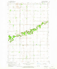
1963 Map of Halstad
USGS Topo · Published 1964About this map
The Red River of the North winds in sharp oxbows through this fertile valley, defining the boundary between Norman and Traill counties. During the early 1960s, the rural landscape around Halstad and Hendrum remained heavily oriented toward the river and the Great Northern rail line. The map illustrates a dense network of local cemeteries and parish life, including Pontoppidan Ch and the St Pauls Cem. Notable water features like Grandin L and the Wild Rice River intersect with man-made infrastructure, such as the Old Railroad Grade and a Radio Tower. These details provide a clear picture of the mid-century agricultural and civic layout, showing the precise location of riverside gaging stations and town parks like Riverside Park.
Find a feature on this map
27 named features on this map. Tap any name to fly to it.
Don’t see what you’re looking for? This feature index may not catch every label — zoom into the map to look around manually.
Map Details
Editions of this 1963 Halstad Map
This is the sole edition of this map. No revisions or reprints were ever made.
Other maps of this area

1918 · Hendrum
USGS Topo · 1:62,500

1924 · Ada
USGS Topo · 1:62,500

1952 · Grand Forks
USGS Topo · 1:250,000

1956 · Grand Forks
USGS Topo · 1:250,000

1963 · Shelly
USGS Topo · 1:24,000

1963 · Perley
USGS Topo · 1:24,000

1963 · Gardner
USGS Topo · 1:24,000

1963 · Halstad SW
USGS Topo · 1:24,000
1964 · Caledonia
USGS Topo · 1:24,000

1965 · Anthony
USGS Topo · 1:24,000