
1963 Map of Shelly
USGS Topo · Published 1964About this map
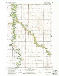
The Red River of the North defines the western border of this 1963 survey, its meandering course carving through the agricultural landscape between Minnesota and North Dakota. At the center of the sheet, the village of Shelly sits along the Great Northern railroad line, serving as a primary hub for this fertile valley community. The map reveals an intricate network of water management, including Ditch No 2, Judicial Ditch No 54, and the Steenerson Drain, all designed to drain the flat prairie into the Marsh River and the Red River.
Find a feature on this map
23 named features on this map. Tap any name to fly to it.
Don’t see what you’re looking for? This feature index may not catch every label — zoom into the map to look around manually.
Map Details
Editions of this 1963 Shelly Map
2 editions found
Other maps of this area

1918 · Hendrum
USGS Topo · 1:62,500

1919 · Eldred
USGS Topo · 1:62,500

1919 · Beltrami
USGS Topo · 1:62,500

1924 · Ada
USGS Topo · 1:62,500

1952 · Grand Forks
USGS Topo · 1:250,000

1956 · Grand Forks
USGS Topo · 1:250,000

1963 · Halstad
USGS Topo · 1:24,000

1963 · Halstad SW
USGS Topo · 1:24,000

1964 · Beltrami SW
USGS Topo · 1:24,000

1964 · Climax SW
USGS Topo · 1:24,000