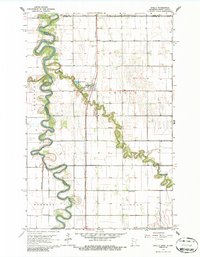
1963 Map of Shelly
USGS Topo · Published 1986About this map
The meandering Red River forms a complex boundary between Minnesota and North Dakota, its deep loops and oxbows defining the western edge of this 1963 survey. The settlement of Shelly serves as a local hub along the Great Northern railroad line, surrounded by a highly organized landscape of agricultural drainage such as Judicial Ditch No 54 and County Ditch No 9. This survey reveals a community deeply rooted in its local institutions, evidenced by the numerous cemeteries and country churches dotting the prairie, including St Petri Cem, Zion Ch, and Augustana Ch. Further south, the Herberg Sch stands as a marker of the era's rural education system. The convergence of the Marsh River and Goose River with the Red River highlights the region's complex hydrology, managed by infrastructure like the Gaging Station and various man-made drains.
Find a feature on this map
26 named features on this map. Tap any name to fly to it.
Don’t see what you’re looking for? This feature index may not catch every label — zoom into the map to look around manually.
Map Details
Editions of this 1963 Shelly Map
2 editions found
Other maps of this area

1918 · Hendrum
USGS Topo · 1:62,500

1919 · Eldred
USGS Topo · 1:62,500

1919 · Beltrami
USGS Topo · 1:62,500

1924 · Ada
USGS Topo · 1:62,500

1952 · Grand Forks
USGS Topo · 1:250,000

1956 · Grand Forks
USGS Topo · 1:250,000

1963 · Shelly
USGS Topo · 1:24,000

1963 · Halstad
USGS Topo · 1:24,000

1963 · Halstad SW
USGS Topo · 1:24,000

1964 · Beltrami SW
USGS Topo · 1:24,000