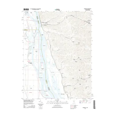
2015 Map of Hamburg
USGS Topo · Published 2015About this map
The Mississippi River serves as the central artery for this Illinois and Missouri borderland, defining a complex network of side channels and islands. In the eastern uplands of Calhoun County, the topography is carved by numerous drainage systems including Gresham Hollow, Poor Farm Hollow, and McNabb Hollow. Local heritage is preserved through family and community landmarks such as Gresham Cem, Mount Hope Cem, and Oak Grove Cem, which are situated on the high ground overlooking the river valley. The river itself is filled with significant landforms like Westport Island and Eagle Island, separated from the mainland by routes such as Westport Chute. These waterways and their associated landings, including Old Westport Landing, reflect the long-standing maritime and agricultural dependence of settlements like Hamburg and Star City. The eastern edge transitions into a ridge-and-valley landscape featuring Blue Ridge and Anderson Hill, which overlook the small community of Hardin.
Find a feature on this map
103 named features on this map. Tap any name to fly to it.
Don’t see what you’re looking for? This feature index may not catch every label — zoom into the map to look around manually.
Map Details
Editions of this 2015 Hamburg Map
This is the sole edition of this map. No revisions or reprints were ever made.
Other maps of this area

1930 · Pearl
USGS Topo · 1:62,500

1930 · Nebo
USGS Topo · 1:62,500

1930 · Hardin
USGS Topo · 1:62,500

1934 · Nebo
USGS Topo · 1:48,000

1934 · Elsberry
USGS Topo · 1:48,000

1934 · Hardin
USGS Topo · 1:62,500

1938 · Hardin
USGS Topo · 1:62,500

1942 · Nebo
USGS Topo · 1:62,500

1942 · Elsberry
USGS Topo · 1:62,500

1948 · Quincy
USGS Topo · 1:250,000