1978 Map of Hamburg
USGS Topo · Published 1978About this map
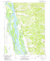
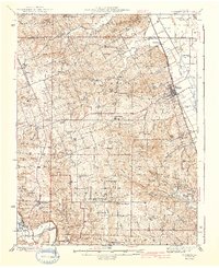
Hamburg and the rugged blufflands of Dividing Ridge define this riverfront landscape in the late 1970s. This survey detail follows the shifting channels of the Mississippi River, where the Hamburg Ferry still provided a vital crossing link between Illinois and Missouri. The river valley is a complex network of backwaters and islands including Westport Island and Sterling Island, much of which is preserved within the Upper Mississippi River State Wildlife Management Area.
Find a feature on this map
80 named features on this map. Tap any name to fly to it.
Don’t see what you’re looking for? This feature index may not catch every label — zoom into the map to look around manually.
Map Details
Editions of this 1978 Hamburg Map
This is the sole edition of this map. No revisions or reprints were ever made.
Other maps of this area

1930 · Pearl
USGS Topo · 1:62,500

1930 · Nebo
USGS Topo · 1:62,500

1930 · Hardin
USGS Topo · 1:62,500
1934 · Nebo
USGS Topo · 1:48,000
1934 · Elsberry
USGS Topo · 1:48,000

1934 · Hardin
USGS Topo · 1:62,500

1938 · Hardin
USGS Topo · 1:62,500
1942 · Nebo
USGS Topo · 1:62,500
1942 · Elsberry
USGS Topo · 1:62,500

1948 · Quincy
USGS Topo · 1:250,000