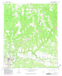
1967 Map of Hamilton
USGS Topo · Published 1983About this map
The Buttahatchee River winds across this Marion County landscape, anchoring the development of Hamilton and surrounding rural communities. During this mid-century period, the area maintained a network of traditional social centers, including the Shiloh Sch and numerous country churches such as Antioch Ch and Mt Hope Ch. The topography reveals a complex drainage system where Williams Creek and Sevenmile Creek feed into the river valley, shaping the layout of early roads and settlements like Pleasant Ridge.
Find a feature on this map
42 named features on this map. Tap any name to fly to it.
Don’t see what you’re looking for? This feature index may not catch every label — zoom into the map to look around manually.
Map Details
Editions of this 1967 Hamilton Map
2 editions found
Other maps of this area

1936 · Hodges
USGS Topo · 1:24,000

1936 · South Of Hackleburg
USGS Topo · 1:24,000

1936 · Hackleburg
USGS Topo · 1:24,000

1936 · Vina
USGS Topo · 1:24,000

1946 · Hackleburg
USGS Topo · 1:24,000
1948 · Hackleburg
USGS Topo · 1:24,000

1949 · Hodges
USGS Topo · 1:24,000

1950 · Vina
USGS Topo · 1:24,000

1951 · Vina
USGS Topo · 1:24,000

1956 · Gadsden
USGS Topo · 1:250,000