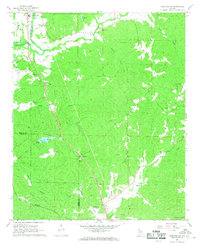
1967 Map of Hamilton SW
USGS Topo · Published 1968About this map
Pikeville sits at a geographic crossroads in Marion County, serving as a focal point for a community defined by its rural institutions and small-scale industry in the late 1960s. The landscape is dotted with family and community landmarks such as Pikeville Cem, Terrell Cem, and Philadelphia Ch, reflecting a deep-rooted social fabric. To the north, the Buttahatchee River meanders near the Hamilton corporate boundary, while the Marion County Airport and the Northwest Alabama State Trade Sch indicate the era's growing infrastructure. Numerous gravel pits and drill holes are scattered throughout the quadrangle, illustrating the importance of local extraction and materials to the local economy. The network of creeks, including Whitley Creek and Beaver Creek, feeds into County Lake, highlighting a terrain where natural water resources and recreational spaces like Pikeville Country Club intersect.
Find a feature on this map
46 named features on this map. Tap any name to fly to it.
Don’t see what you’re looking for? This feature index may not catch every label — zoom into the map to look around manually.
Map Details
Editions of this 1967 Hamilton SW Map
2 editions found
Other maps of this area

1936 · South Of Hackleburg
USGS Topo · 1:24,000

1953 · Birmingham
USGS Topo · 1:250,000

1953 · West Point
USGS Topo · 1:250,000

1956 · Birmingham
USGS Topo · 1:250,000

1956 · Gadsden
USGS Topo · 1:250,000

1956 · Tupelo
USGS Topo · 1:250,000

1957 · Birmingham
USGS Topo · 1:250,000

1958 · Tupelo
USGS Topo · 1:250,000

1958 · West Point
USGS Topo · 1:250,000

1958 · Gadsden
USGS Topo · 1:250,000