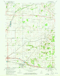
1969 Map of Hamlet
USGS Topo · Published 1971About this map
Hamlet serves as a central hub in this northern Indiana landscape, where the Penn Central railroad corridors converge near the Fairgrounds and a local Township Sch. The geography is defined by an extensive network of drainage infrastructure, including the Johanni Ditch, Amy Kelley Ditch, and Robbins Ditch, which manage the low-lying terrain surrounding the Kankakee River. To the north, the Kingsbury State Fish and Game Area occupies a significant portion of the land, abutting a U S Military Reservation. The map traces the historical path of the Yellowstone Trail and various rural routes like Benninghoff Road and Tracy Road, illustrating the intersection of early automotive highways with the area's established rail and agricultural framework near Grovertown.
Find a feature on this map
57 named features on this map. Tap any name to fly to it.
Don’t see what you’re looking for? This feature index may not catch every label — zoom into the map to look around manually.
Map Details
Editions of this 1969 Hamlet Map
2 editions found
Other maps of this area

1953 · Chicago
USGS Topo · 1:250,000

1957 · Chicago
USGS Topo · 1:250,000

1957 · Knox East
USGS Topo · 1:24,000

1957 · Knox West
USGS Topo · 1:24,000

1958 · Donaldson
USGS Topo · 1:24,000

1958 · Kingsford Heights
USGS Topo · 1:24,000

1958 · Hamlet
USGS Topo · 1:24,000

1958 · Walkerton
USGS Topo · 1:24,000

1958 · Stillwell
USGS Topo · 1:24,000

1958 · North Liberty
USGS Topo · 1:24,000