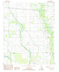
1984 Map of Hamlin
USGS Topo · Published 1985About this map
L'Anguille River meanders through the eastern portion of this landscape, its complex floodplains and backwaters defining the geography of the Cross County and St. Francis County border. The agricultural character of the region in the early 1980s is evident in the network of irrigation ditches and straightened channels like First Creek and Second Creek, which manage water across the flat terrain. The small community of Hamlin serves as a local focal point near the northern edge, while Ellis Chapel stands as a quiet landmark along Malone Branch. To the south, the settlement of Pinetree marks the lower reaches of the survey area. This map documents a period when traditional watercourses like Brushy Creek and Lick Creek existed alongside a highly engineered landscape of siphons and canals, essential for the delta's farming economy.
Find a feature on this map
12 named features on this map. Tap any name to fly to it.
Don’t see what you’re looking for? This feature index may not catch every label — zoom into the map to look around manually.
Map Details
Editions of this 1984 Hamlin Map
2 editions found
Other maps of this area

1939 · Vanndale
USGS Topo · 1:62,500

1939 · Wynne
USGS Topo · 1:62,500

1939 · Hunter
USGS Topo · 1:62,500

1940 · Tilton
USGS Topo · 1:62,500

1953 · Memphis
USGS Topo · 1:250,000

1956 · Memphis
USGS Topo · 1:250,000

1956 · Tilton
USGS Topo · 1:62,500

1956 · Hunter
USGS Topo · 1:62,500

1958 · Hunter
USGS Topo · 1:62,500

1958 · Wynne
USGS Topo · 1:62,500