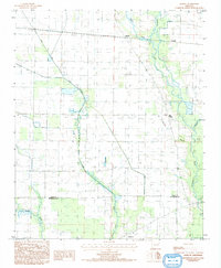
1984 Map of Hamlin
USGS Topo · Published 1993About this map
The L'Anguille River meanders through this agricultural section of the Arkansas Delta, defining much of the drainage and land-use patterns during the early 1980s. The small settlement of Hamlin serves as a local focal point near the northern edge, while the crossing of Cross Co St Francis Co line in the south marks the transition between neighboring jurisdictions. The landscape is characterized by a dense network of watercourses including Brushy Creek, First Creek, and Second Creek, alongside human-engineered features like fish ponds and irrigation canals.
Find a feature on this map
13 named features on this map. Tap any name to fly to it.
Don’t see what you’re looking for? This feature index may not catch every label — zoom into the map to look around manually.
Map Details
Editions of this 1984 Hamlin Map
2 editions found
Other maps of this area

1939 · Vanndale
USGS Topo · 1:62,500

1939 · Wynne
USGS Topo · 1:62,500

1939 · Hunter
USGS Topo · 1:62,500

1940 · Tilton
USGS Topo · 1:62,500

1953 · Memphis
USGS Topo · 1:250,000

1956 · Memphis
USGS Topo · 1:250,000

1956 · Tilton
USGS Topo · 1:62,500

1956 · Hunter
USGS Topo · 1:62,500

1958 · Hunter
USGS Topo · 1:62,500

1958 · Wynne
USGS Topo · 1:62,500