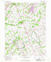
1944 Map of Hampton
USGS Topo · Published 1969About this map
Conewago Creek and its winding tributaries, including Bermudian Creek and Red Run, define the rural landscape of Adams County as it appeared mid-century. The settlement of Hampton sits at the crossroads of this agricultural region, which is notably dense with small district schools that reflect an older era of community organization. These include uniquely named sites like Seven Hundred Sch, Victory Sch, and Independence Sch.
Find a feature on this map
41 named features on this map. Tap any name to fly to it.
Don’t see what you’re looking for? This feature index may not catch every label — zoom into the map to look around manually.
Map Details
Editions of this 1944 Hampton Map
5 editions found

Other maps of this area

1904 · Carlisle
USGS Topo · 1:62,500

1906 · New Cumberland
USGS Topo · 1:62,500

1908 · Gettysburg
USGS Topo · 1:62,500

1920 · Hanover
USGS Topo · 1:62,500

1922 · Hanover
USGS Topo · 1:62,500

1942 · Gettysburg
USGS Topo · 1:125,000

1943 · New Cumberland
USGS Topo · 1:62,500

1943 · Carlisle
USGS Topo · 1:62,500

1944 · Gettysburg
USGS Topo · 1:31,680

1944 · Mc Sherrystown
USGS Topo · 1:31,680
Featured Places
- Latimore Township, PA
- Huntington Township, PA
- Mount Pleasant Township, PA
- Hamilton Township, PA
- Oxford Township, PA