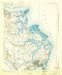
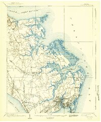
1907 Map of Hampton
USGS Topo · Published 1932About this map
Big Bethel Battlefield and the surrounding coastal necks of the Virginia Peninsula are preserved here in a 1907 survey reprinted during the early 1930s. The landscape reflects a mix of military history and early 20th-century institutional growth, anchored by Fort Monroe at Old Point Comfort and the expanding Langley Field near Tabbs Creek. The map documents numerous vanished local landmarks and family-named landings, from Amorys Wharf to the Hampton Normal School and its associated Hampton Normal School Farm. Transportation is defined by a dense network of country roads like Yorktown Road and the specialized Hampton and Old Point Electric RR. Between the Poquoson River and the James River, the map captures a period when small communities like Messick, Odd, and Tampico were still primarily connected by tide-water creeks and light rail before the massive suburban expansion of the later century.
Find a feature on this map
88 named features on this map. Tap any name to fly to it.
Don’t see what you’re looking for? This feature index may not catch every label — zoom into the map to look around manually.
Map Details
Editions of this 1907 Hampton Map
6 editions found
Other maps of this area

1906 · Williamsburg
USGS Topo · 1:62,500

1907 · Norfolk
USGS Topo · 1:125,000

1907 · Yorktown
USGS Topo · 1:62,500

1907 · Hampton
USGS Topo · 1:62,500

1916 · Mathews
USGS Topo · 1:62,500

1917 · Mathews
USGS Topo · 1:62,500

1918 · Cape Henry
USGS Topo · 1:62,500

1919 · Smithfield
USGS Topo · 1:62,500

1919 · Cape Henry
USGS Topo · 1:62,500

1921 · Newport News
USGS Topo · 1:62,500