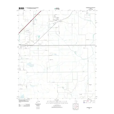
2013 Map of Hamshire
USGS Topo · Published 2013About this map
Hamshire serves as the central hub of this coastal prairie landscape, where a dense grid of rural roads meets the sprawling industrial footprint of the Texas Gulf Coast. The region is defined by its extensive energy infrastructure, visible through the Stowell Oil Field, South Stowell Oil Field, and Big Hill Oil Field. These fields, along with the Fannett Oil Field to the northeast, signify the long-standing importance of petroleum extraction to the local economy. Waterways like S Fork Taylor Bayou and Mayhaw Bayou meander through the flat terrain, occasionally collected into reservoirs such as Marshall Estate Lake Number 2. Small-scale aviation supports the local agricultural and ranching operations, evidenced by the Griffith Ranch Airport and Wilber Farms Airport. Near the town center, the Woodrow Cem offers a point of interest for genealogists tracing the legacy of early settlers in Jefferson County.
Find a feature on this map
65 named features on this map. Tap any name to fly to it.
Don’t see what you’re looking for? This feature index may not catch every label — zoom into the map to look around manually.
Map Details
Editions of this 2013 Hamshire Map
This is the sole edition of this map. No revisions or reprints were ever made.
Other maps of this area

1943 · Sea Breeze
USGS Topo · 1:24,000

1943 · Stowell
USGS Topo · 1:24,000

1943 · Fannett East
USGS Topo · 1:24,000

1945 · Fannett East
USGS Topo · 1:31,680

1945 · Nolte
USGS Topo · 1:31,680

1945 · Sea Breeze
USGS Topo · 1:31,680

1950 · Houston
USGS Topo · 1:250,000

1956 · Houston
USGS Topo · 1:250,000

1961 · Star Lake
USGS Topo · 1:24,000
1962 · Stanolind Reservoir
USGS Topo · 1:24,000