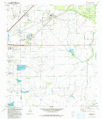
1994 Map of Hamshire
USGS Topo · Published 1994About this map
The low-lying coastal plains of Jefferson and Chambers counties are defined by a complex network of bayous and petroleum extraction. Centered on the communities of Hamshire and Winnie, the landscape is heavily etched with the infrastructure of the Gulf Coast energy economy. To the south, the Strategic Petroleum Reserve Big Hill occupies a prominent position near Big Hill, while multiple active production zones such as the North Winnie Field and South Stowell Oil Field dot the map with numerous oil and gas wells.
Find a feature on this map
26 named features on this map. Tap any name to fly to it.
Don’t see what you’re looking for? This feature index may not catch every label — zoom into the map to look around manually.
Map Details
Editions of this 1994 Hamshire Map
This is the sole edition of this map. No revisions or reprints were ever made.
Other maps of this area

1943 · Sea Breeze
USGS Topo · 1:24,000

1943 · Stowell
USGS Topo · 1:24,000

1943 · Fannett East
USGS Topo · 1:24,000

1945 · Fannett East
USGS Topo · 1:31,680

1945 · Nolte
USGS Topo · 1:31,680

1945 · Sea Breeze
USGS Topo · 1:31,680

1950 · Houston
USGS Topo · 1:250,000

1956 · Houston
USGS Topo · 1:250,000

1961 · Star Lake
USGS Topo · 1:24,000
1962 · Stanolind Reservoir
USGS Topo · 1:24,000