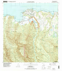
1996 Map of Hanalei
USGS Topo · Published 1998About this map
The Hanalei River carves a deep valley through this northern Kauai landscape, where the alluvial flats support the Hanalei National Wildlife Refuge. The settlement of Hanalei sits along the curve of Hanalei Bay, while the planned community of Princeville occupies the bluffs to the east, complete with its Golf Course and nearby Princeville Airport. The interior is defined by massive land divisions such as the Halelea Forest Reserve and the Hanalei Forest Reserve, rising toward the peaks of Namolokama Mountain and Hihimanu. Along the coast, numerous points and beaches like Anini Beach and Makahoa Point separate the river mouths. For those researching local history, the map shows legacy sites including Hanapai and the old Hanalei Landing, providing a detailed view of the region's infrastructure before the close of the twentieth century.
Find a feature on this map
62 named features on this map. Tap any name to fly to it.
Don’t see what you’re looking for? This feature index may not catch every label — zoom into the map to look around manually.
Map Details
Editions of this 1996 Hanalei Map
This is the sole edition of this map. No revisions or reprints were ever made.
Other maps of this area

1954 · Kauai
USGS Topo · 1:250,000

1963 · Anahola
USGS Topo · 1:24,000

1963 · Kapaa
USGS Topo · 1:24,000

1963 · Hanalei
USGS Topo · 1:24,000

1965 · Waimea Canyon
USGS Topo · 1:24,000

1965 · Haena
USGS Topo · 1:24,000

1965 · Waialeale
USGS Topo · 1:24,000

1967 · Kauai
USGS Topo · 1:250,000

1970 · Kauai
USGS Topo · 1:250,000

1978 · Kapaa
USGS Topo · 1:24,000