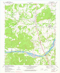
1971 Map of Hanna
USGS Topo · Published 1977About this map
The Canadian River flows across the lower portion of this quadrangle, defining the winding boundary between McIntosh and Pittsburg counties. In the early 1970s, the landscape here shows a transition toward modern infrastructure with the prominent Indian Nation Toll Road cutting north-south through the center of the sheet, even as the older Old Railroad Grade traces a horizontal path past the settlement of Vernon.
Find a feature on this map
22 named features on this map. Tap any name to fly to it.
Don’t see what you’re looking for? This feature index may not catch every label — zoom into the map to look around manually.
Map Details
Editions of this 1971 Hanna Map
2 editions found
Other maps of this area

1900 · Canadian
USGS Topo · 1:125,000

1900 · Wewoka
USGS Topo · 1:125,000

1946 · Fort Smith
USGS Topo · 1:250,000

1954 · Oklahoma City
USGS Topo · 1:250,000

1957 · Oklahoma City
USGS Topo · 1:250,000

1962 · Raiford
USGS Topo · 1:24,000

1962 · Henryetta SW
USGS Topo · 1:24,000

1963 · Oklahoma City
USGS Topo · 1:250,000

1965 · Fort Smith
USGS Topo · 1:250,000

1967 · Fort Smith
USGS Topo · 1:250,000