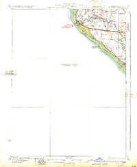
1932 Map of Hannibal
USGS Topo · Published 1932About this map
The Mississippi River dominates this preliminary survey, dividing the Illinois bottomlands from the Missouri riverfront. On the Illinois side, the landscape is defined by an intricate network of waterways such as The Sny and Bird Slough, which weave through the agricultural flats of Pike County. This era of settlement is marked by numerous rural schoolhouses, including the Rouse Sch and Running Slough Sch, positioned to serve farming families living behind the river's levees.
Find a feature on this map
39 named features on this map. Tap any name to fly to it.
Don’t see what you’re looking for? This feature index may not catch every label — zoom into the map to look around manually.
Map Details
Editions of this 1932 Hannibal Map
4 editions found
Other maps of this area

1890 · Louisiana
USGS Topo · 1:125,000

1890 · Mexico
USGS Topo · 1:125,000

1903 · Palmyra
USGS Topo · 1:125,000

1925 · Quincy
USGS Topo · 1:62,500

1925 · Liberty
USGS Topo · 1:62,500

1927 · Liberty
USGS Topo · 1:62,500

1931 · Barry
USGS Topo · 1:62,500

1932 · Hannibal
USGS Topo · 1:62,500

1936 · Hannibal
USGS Topo · 1:48,000

1936 · Barry
USGS Topo · 1:48,000