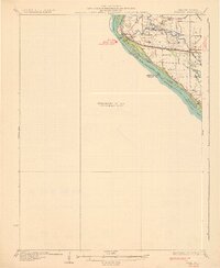
1932 Map of Hannibal
USGS Topo · Published 1932About this map
Mississippi River dynamics dominate this 1932 preliminary survey, which illustrates the complex network of sloughs, chutes, and islands across from Hannibal. The landscape is defined by the intricate hydrology of The Sny and the numerous waterways that bypass the main channel, including Bird Slough and Running Slough. This edition is particularly valuable for its depiction of the river before modern engineering further altered these bottomlands, showing the location of several rural schoolhouses such as the Old Smith Sch and Rouse Sch that served isolated riverside communities.
Find a feature on this map
32 named features on this map. Tap any name to fly to it.
Don’t see what you’re looking for? This feature index may not catch every label — zoom into the map to look around manually.
Map Details
Editions of this 1932 Hannibal Map
4 editions found
Other maps of this area

1890 · Louisiana
USGS Topo · 1:125,000

1890 · Mexico
USGS Topo · 1:125,000

1903 · Palmyra
USGS Topo · 1:125,000

1925 · Quincy
USGS Topo · 1:62,500

1925 · Liberty
USGS Topo · 1:62,500

1927 · Liberty
USGS Topo · 1:62,500

1931 · Barry
USGS Topo · 1:62,500

1932 · Hannibal
USGS Topo · 1:62,500

1936 · Hannibal
USGS Topo · 1:48,000

1936 · Barry
USGS Topo · 1:48,000