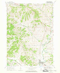
1968 Map of Hanover
USGS Topo · Published 1970About this map
The Apple River snakes through the landscape of Jo Daviess County, defining the valley that contains Hanover and North Hanover. This late-1960s survey illustrates a region where transportation and military infrastructure intersect with traditional rural settlements. The southern portion of the sheet is dominated by the sprawling boundaries of the Savanna Army Depot, while the Chicago and North Western and Chicago Burlington and Quincy railroads facilitate movement through the rugged topography. Genealogists and local historians will find the Weston Cem and Log Church Cem as important anchors for early family research. The map also records small communities like Winston and Rodden, and numerous geological features including Irish Hollow and Beaty Hollow, reflecting the complex drainage patterns and economic extraction at various Quarry and Gravel Pit sites.
Find a feature on this map
27 named features on this map. Tap any name to fly to it.
Don’t see what you’re looking for? This feature index may not catch every label — zoom into the map to look around manually.
Map Details
Editions of this 1968 Hanover Map
3 editions found
Other maps of this area

1892 · Savanna
USGS Topo · 1:62,500

1911 · Elizabeth
USGS Topo · 1:62,500

1911 · Galena
USGS Topo · 1:62,500

1913 · Galena
USGS Topo · 1:62,500

1935 · Miles
USGS Topo · 1:62,500

1936 · Elizabeth
USGS Topo · 1:62,500

1941 · Miles
USGS Topo · 1:62,500

1952 · Savanna
USGS Topo · 1:62,500

1953 · Blackhawk
USGS Topo · 1:24,000

1953 · Green Island
USGS Topo · 1:24,000