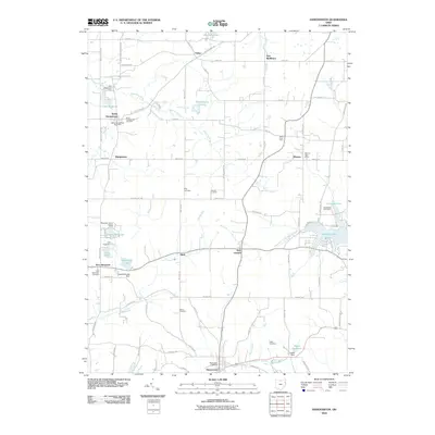
2010 Map of Hanoverton
USGS Topo · Published 2010About this map
The Mahoning River flows through the northern reaches of this Columbiana County landscape, anchoring a rural territory defined by small agricultural settlements and managed water resources. Local industry and land use are evidenced by landmarks like the Burch Dairy Farm and Vincents Orchards, while several small reservoirs including Lake Placentia and Zepernick Lake point to local water management for recreation or agriculture. The village of Hanoverton occupies the southern edge, serving as a focal point alongside other historic crossroads like North Georgetown and Winona. Genealogists will find significant value in the distribution of family-named sites and rural burial grounds, such as King Cemetery, Dutton Cemetery, and Figley Cemetery, which provide a clear record of established local lineages within this traditional Ohio farming community.
Find a feature on this map
74 named features on this map. Tap any name to fly to it.
Don’t see what you’re looking for? This feature index may not catch every label — zoom into the map to look around manually.
Map Details
Editions of this 2010 Hanoverton Map
This is the sole edition of this map. No revisions or reprints were ever made.
Other maps of this area

1905 · Salineville
USGS Topo · 1:62,500

1909 · Alliance
USGS Topo · 1:62,500

1909 · Lisbon
USGS Topo · 1:62,500

1910 · Carrollton
USGS Topo · 1:62,500

1912 · Carrollton
USGS Topo · 1:62,500

1951 · Canton
USGS Topo · 1:250,000

1952 · Alliance
USGS Topo · 1:24,000

1952 · Damascus
USGS Topo · 1:24,000
1952 · Salem
USGS Topo · 1:24,000

1953 · Canton
USGS Topo · 1:250,000