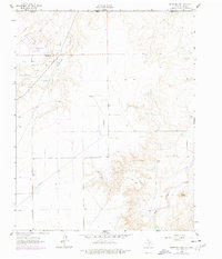
1962 Map of Hansford Camp
USGS Topo · Published 1977About this map
The Oklahoma-Texas border bisects this High Plains landscape, where the agricultural and industrial character of Hansford County is clearly defined. The settlement at Hansford Camp sits alongside Hitchland, serving as a focal point for the extensive energy infrastructure of the Hitchland Gas and Oil Field. This survey captures a moment when the region's economy was deeply tied to these resources, evidenced by the numerous pipelines and wells spidering across the terrain north of the Spearman North Gas and Oil Field.
Find a feature on this map
15 named features on this map. Tap any name to fly to it.
Don’t see what you’re looking for? This feature index may not catch every label — zoom into the map to look around manually.
Map Details
Editions of this 1962 Hansford Camp Map
2 editions found
Other maps of this area

1954 · Perryton
USGS Topo · 1:250,000

1958 · Perryton
USGS Topo · 1:250,000

1962 · Kimball
USGS Topo · 1:24,000

1962 · Hansford Camp
USGS Topo · 1:24,000

1962 · Waka SW
USGS Topo · 1:24,000

1968 · Hardesty
USGS Topo · 1:24,000

1968 · Hardesty SE
USGS Topo · 1:24,000

1968 · Guymon SE
USGS Topo · 1:24,000

1973 · Horseshoe Hill
USGS Topo · 1:24,000

1973 · Waka
USGS Topo · 1:24,000