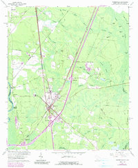
1962 Map of Hardeeville
USGS Topo · Published 1990About this map
The Savannah River serves as the western boundary of this coastal plain landscape, where the Lowcountry terrain transitions into a complex network of wetlands and pine forests. Hardeeville sits at the junction of the Southern and Seaboard Coast Line railroads, its mid-century growth influenced by the convergence of the Old Charleston Road and the Becks Ferry Road. Significant family and religious landmarks are scattered through the area, including the White Hardee Cem and Mt Calvary Ch, reflecting deep-seated local genealogies.
Find a feature on this map
67 named features on this map. Tap any name to fly to it.
Don’t see what you’re looking for? This feature index may not catch every label — zoom into the map to look around manually.
Map Details
Editions of this 1962 Hardeeville Map
4 editions found
Other maps of this area

1920 · Hardeeville
USGS Topo · 1:62,500

1920 · Okatie
USGS Topo · 1:62,500

1920 · Bluffton
USGS Topo · 1:62,500

1942 · Savannah
USGS Topo · 1:62,500

1942 · Okatie
USGS Topo · 1:62,500

1943 · Hardeeville
USGS Topo · 1:62,500

1945 · Bluffton
USGS Topo · 1:62,500

1947 · Savannah
USGS Topo · 1:250,000

1948 · Savannah
USGS Topo · 1:250,000

1953 · Hardeeville
USGS Topo · 1:62,500