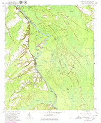
1962 Map of Hardeeville NW
USGS Topo · Published 1980About this map
The Savannah River defines the border between Georgia and South Carolina, anchoring a landscape of river landings and lowland swamps. On the Georgia side, the settlement of Stillwell and the historic Ebenezer Ch stand near the riverbanks, while the South Carolina side features numerous named landings like Sisters Ferry Landing and Gatneys Landing. The river itself is characterized by intricate meanders and named points such as Chair Maker Point and Bowl Maker Point, reflecting a history of local navigation and river-based commerce. Inland from the water, the terrain rises into the Sand Hills, where landmarks like the Green Swamp Hunting Lodge and Beech Hill suggest the area's use for timber and recreation. For genealogists, the map preserves the locations of the Union Spring Cem and Strohbar Cem, alongside small rural communities like Haddonville and Keiffer.
Find a feature on this map
82 named features on this map. Tap any name to fly to it.
Don’t see what you’re looking for? This feature index may not catch every label — zoom into the map to look around manually.
Map Details
Editions of this 1962 Hardeeville NW Map
2 editions found
Other maps of this area

1919 · Pineland
USGS Topo · 1:62,500

1919 · Shirley
USGS Topo · 1:62,500

1919 · Egypt
USGS Topo · 1:62,500

1920 · Hardeeville
USGS Topo · 1:62,500

1939 · Egypt
USGS Topo · 1:62,500

1943 · Pineland
USGS Topo · 1:62,500

1943 · Hardeeville
USGS Topo · 1:62,500

1943 · Egypt
USGS Topo · 1:62,500

1943 · Shirley
USGS Topo · 1:62,500

1947 · Savannah
USGS Topo · 1:250,000