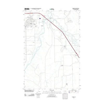
2011 Map of Hardin
USGS Topo · Published 2011About this map
Hardin serves as the primary hub of this landscape, situated near the significant confluence of the Bighorn River and the Little Bighorn River. The town's infrastructure is clearly defined, featuring the Big Horn County Fairgrounds, Hardin Post Office, and the Fairgrounds Airpark. Transportation through the Little Bighorn Valley is dominated by the corridor of the BNSF Railway, which runs parallel to major roads and connects smaller localities like Reno and Dunmore. The river geography is central to the area's development, highlighted by the Big Horn River Bridge and engineering features such as the Hardin Sewage Lagoon Dam. To the south, the map documents specialized sites including Campbell Camp Number One and the Crow Number 22 Dam, reflecting a mix of agricultural, civic, and water-management uses in this part of Montana.
Find a feature on this map
32 named features on this map. Tap any name to fly to it.
Don’t see what you’re looking for? This feature index may not catch every label — zoom into the map to look around manually.
Map Details
Editions of this 2011 Hardin Map
This is the sole edition of this map. No revisions or reprints were ever made.
Other maps of this area

1894 · Fort Custer
USGS Topo · 1:125,000

1954 · Hardin
USGS Topo · 1:250,000

1957 · Hardin
USGS Topo · 1:250,000

1958 · Hardin
USGS Topo · 1:250,000

1960 · Ninemile Point
USGS Topo · 1:24,000

1960 · Chimney Creek
USGS Topo · 1:24,000

1960 · Walker Hill
USGS Topo · 1:24,000

1960 · Hardin
USGS Topo · 1:24,000
1960 · Prante Ranch
USGS Topo · 1:24,000

1960 · Hardin SW
USGS Topo · 1:24,000