
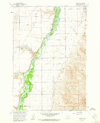
1960 Map of Hardin SW
USGS Topo · Published 1962About this map
The Bighorn River carves a braided path through this Big Horn County landscape, defined by a series of steep drainages and coulees that feed into the river valley. In the early 1960s, this area reflects the rural ranching character of southern Montana, centered around localized operations like Prante Ranch and the Kopac Camp. The topographical detail reveals a complex network of seasonal watercourses with evocative local names such as Whiskey Coulee, Halfway House Coulee, and Good Horse Coulee, suggesting historical transit routes through the dry upland terrain. To the west, Walker Hill stands as a prominent elevation, while the presence of a Gravel Pit and scattered Jeep Trails indicates the small-scale industrial and utility access points used by local residents and the U.S. Bureau of Reclamation during the mid-century development of the Missouri River Basin.
Find a feature on this map
15 named features on this map. Tap any name to fly to it.
Don’t see what you’re looking for? This feature index may not catch every label — zoom into the map to look around manually.
Map Details
Editions of this 1960 Hardin SW Map
2 editions found
Other maps of this area

1894 · St. Xavier
USGS Topo · 1:125,000

1894 · Fort Custer
USGS Topo · 1:125,000

1901 · St. Xavier
USGS Topo · 1:125,000

1954 · Hardin
USGS Topo · 1:250,000

1957 · Hardin
USGS Topo · 1:250,000

1958 · Hardin
USGS Topo · 1:250,000

1960 · St Xavier
USGS Topo · 1:24,000

1960 · Walker Hill
USGS Topo · 1:24,000

1960 · St Xavier NE
USGS Topo · 1:24,000

1960 · Hardin
USGS Topo · 1:24,000