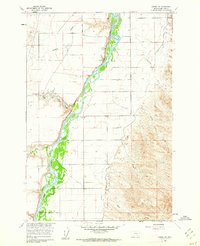
1960 Map of Hardin SW
USGS Topo · Published 1962About this map
The Bighorn River carves a complex, braided path through this portion of Big Horn County, Montana, as documented in this 1960 field study. The landscape is defined by the sharp transition between the irrigated river bottom and the elevated, dry uplands of Walker Hill. This environment supported localized activity like Kopac Camp, situated near the confluence of Whiskey Coulee and Wild Horse Spring. Numerous drainage features like Woody Creek and Halfway House Coulee illustrate the region's erosional patterns and the vital importance of seasonal water sources in the semi-arid northern plains. The map's detail on ephemeral springs and named coulees like Egnew Coulee and Davis Coulee provides essential data for understanding the historical land use and cattle-ranching infrastructure of the mid-20th century.
Find a feature on this map
15 named features on this map. Tap any name to fly to it.
Don’t see what you’re looking for? This feature index may not catch every label — zoom into the map to look around manually.
Map Details
Editions of this 1960 Hardin SW Map
2 editions found

Other maps of this area

1894 · St. Xavier
USGS Topo · 1:125,000

1894 · Fort Custer
USGS Topo · 1:125,000

1901 · St. Xavier
USGS Topo · 1:125,000

1954 · Hardin
USGS Topo · 1:250,000

1957 · Hardin
USGS Topo · 1:250,000

1958 · Hardin
USGS Topo · 1:250,000

1960 · St Xavier
USGS Topo · 1:24,000

1960 · Walker Hill
USGS Topo · 1:24,000

1960 · St Xavier NE
USGS Topo · 1:24,000

1960 · Hardin
USGS Topo · 1:24,000